
SonaSoft 4.2 Update Available
Local History Mapping™ data can now be backed up to FarSounder’s data server and shared anonymously across the FarSounder fleet for the benefit of other users and global data ocean data initiatives. This release also adds the ability to report observations of marine mammals or other navigation hazards in SonaSoft. Reported observations will be shared anonymously with marine mammal and ocean debris tracking organizations for the benefit of ocean science and all mariners.
This release also brings a host of internal and tooling updates that translate into a more robust and overall higher performing system. You'll also find a number of smaller tweaks to the interface that should make your FarSounder experience more enjoyable including improved support for high resolution displays.

SonaSoft 4.1 Update Available
SonaSoft 4.1 allows users to share their Local History Mapping (LHM) with other users as well as contribute data collected to the Seabed 2030 project via the Datacenter for Digital Bathymetry Crowdsourced Database at NOAA. This builds on top of the recent changes in SonaSoft 4.0 to add the display of Local History Mapping (LHM) to the 3D Viewer, an Auto Zoom mode that lets the user focus on the 3D Range of the system in the 3D Viewer, and other UI updates and improvements.
SonaSoft 4.0 Update Available
SonaSoft 4.0 adds the display of Local History Mapping (LHM) to the 3D Viewer, an Auto Zoom mode that lets the user focus on the 3D Range of the system in the 3D Viewer, and other UI updates and improvements.
In case you haven’t update in a while, 3.17 added support for storing Local History Mapping (LHM) data indefinitely when disk space permits and tide correction is available (via a Total Tides subscription). The display of LHM and 3D data was also improved to help highlight features in the bottom detection. Finally, the chart display was modified to show tide station locations as part of the Total Tides integration.
SonaSoft 3.17 Update Available
SonaSoft 3.17 adds support for storing Local History Mapping (LHM) data indefinitely when disk space permits and tide correction is available (via a Total Tides subscription). The display of LHM and 3D data was also improved to help highlight features in the bottom detection. Finally, the chart display was modified to show tide station locations as part of the Total Tides integration.
This release brings a host of internal and tooling updates that translate into a more robust and overall higher performing system. You'll also find a number of smaller tweaks to the interface that should make your FarSounder experience more enjoyable including improved support for high resolution displays.
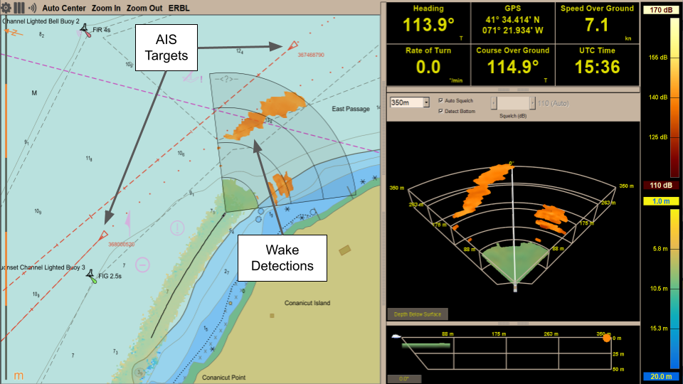
SonaSoft 3.16 Update Available
SonaSoft 3.16 adds support for AIS/ARPA target tracks in the Chart Viewer, building on the introduction of AIS and ARPA targets features added in version 3.15. The bottom is now detected down to 85m, instead of 50m, in situations where the signal is strong enough. Finally, support for connecting NMEA input streams via ethernet was also introduced in this version.
This release brings a host of internal and tooling updates that translate into a more robust and overall higher performing system. You'll also find a number of smaller tweaks to the interface that should make your FarSounder experience more enjoyable including improved support for high resolution displays.