Anything 2D Forward Looking Sonars Can Do, 3D Can Do Better?
By SYT
We pit 2D against 3D to understand what we can expect from different Forward Looking Sonars
With more and more exploration yachts choosing to operate in challenging environments, the risk of collision with poorly charted obstacles, wrongly placed obstacles (due to GPS malfunctions), or transient obstacles such as ice and submerged shipping containers, increases significantly. Groundings with large underwater structures such as rocks, reefs, sandbanks and shoals are unfortunately significant risks. And the annual costs of groundings and collisions run up into the billions every year.
As such, having a navigation sonar capable of detecting such hazards at long range is important in increasing the operator's situational awareness for enhanced navigation and security. Whilst many yachts still use 2D sonars (or ‘3D’ formed of 2D image history stitched together), navigation specialist FarSounder believes that real time 3D sonars can provide a much safer experience. But what advantages does 3D really have over 2D, and with Refit season upon us, are these advantages strong enough to convince the industry to make the switch?
Key metrics
It may seem there are many different metrics to evaluate a sonar's usefulness for navigation, but there are two very important ones: Coverage zone (Field of View/FOV) and Update rate. Both are key in creating a useful tool for navigation. If the field of view is compromised, then there won't be enough usable information to give you a clear picture of what is in front of the boat. Not looking far enough ahead, wide enough to plan an alternative course, or deep enough to understand the bathymetry are all examples of this limitation. On the other hand, even with the best field of view, a sonar that is only updated every couple of minutes is not much help to your yacht when facing an obstacle. Ideally you would want to see what is ahead in real time.
You wouldn’t consider operating large vessels without the use of radar, depth sounders, ECDIS, and/or electronics charts with GPS. But even with these technologies, many yachts are still missing a key piece of information: what is under the water in front of the ship right now.
Shallow waters
When used as a navigation device in shallow water, 2D technologies often fall short of being effective navigation tools. These systems are very good at finding the range and bearing to a single target in deep water. However, in shallow water there are targets at every range and bearing. In this situation 2D systems cannot distinguish between the safe sea floor and the dangerous in-water obstacle through depth measurement. This requires navigators to rely on visual cues and guess whether the obstacles are located in the water column or on the sea floor. The need for visual cues forces those 2D systems to have very high horizontal angular resolution. Unfortunately, this means the systems need many listening channels and a footprint (for the receive array or lens aperture) that is very long in terms of wavelengths. This long aperture requirement drives the systems to a higher frequency, which in turn excludes them from long range capabilities.
Overcoming limitations
A real time 3D processor can tackle this very differently. It is able to create a large field of view with single pings, using fast refreshes to allow for timely navigation when a vessel is underway. The 3D approach enables the system to overcome traditional Forward Looking Sonar limitations such as Multi-Path and Water Depth Issues, Shallow Water Operation, Roll/Pitch Compensation, Surface Effects and Ship Motion. For example, traditional Forward Looking Sonars are unable to compensate for roll and pitch without large amounts of expensive hardware, and even with this the compensation is marginal. On the other hand, the 3D sonar easily overcomes these problems using a simple roll and pitch sensor.
What is ‘real 3D’?
There are many sonars out there which claim to be 3D, but that are not a true 3D sonar. Instead, these are 2D down-looking multibeam. These devices create a 3D image by joining the history of 2D images, but these are images which they have already passed over. This means the data only shows what is directly below and behind them – in most cases this is too late.
Compare 2D & 3D on the screen
To illustrate the difference between these two approaches, consider the following figures.
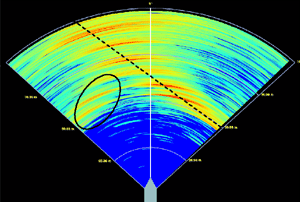
In figure 1 (image right), real data of a pier wall bulkhead collected with a FarSounder 3D sonar system is processed as a simple 2D horizontal slice. In this display, colour is mapped to signal strength where red is "loud" and blue is "quiet". The angular resolution is roughly equal to the existing off-the-shelf Forward Looking Sonars (FLS) -- also called Collision Avoidance Sonar Systems (CASS) or Obstacle Avoidance Sonars (OAS) -- manufactured by various companies. There is clearly a feature caused by the pier wall crossing the field of view at about 45° (noted with the dotted line). Yet there is also another feature or "bright" spot noted by the oval. As a navigation tool, this 2D display is not very effective.
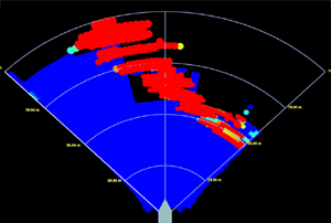
In figure 2 (image right), this same ping has been processed with FarSounder's 3D processing using patented Target Model technology. In this image, colour is mapped to depth. The view is a look down orthographic projection, yet targets are actually plotted in 3D space. Note the clear presence of the pier wall (shallow) in red and the sea floor (deep) in blue.
In figure 3 (image right), the same data is plotted in 3D space with a rotated perspective view. Note how clear it is to see the navigation hazards in 3D with this processing technique.
Conclusions
For Captains who are dissatisfied with the situational awareness on their vessel, this true 3D processing proves a good alternative to 2D. Will we see an industry shift as more yachts switch to true 3D sonars for their navigation? Watch this space.


